Jamaican Family Search Genealogy Research Library
The growth of Kingston brought it new importance in Jamaica, and into competition with the capital, Spanish Town. In 1803, Kingston was incorporated as a city, in recognition of its new prosperity, and in hopes that a Mayor and Council would police the city more vigorously than the old vestry. This measure passed in the teeth of strong opposition from the planting interest, who saw Kingston as the preserve of their rivals, the merchants. But growth and prosperity seem to have done little for the appearance of the city. In 1816, a visitor to the island, Matthew Lewis, provided this description:
"If any person will imagine a large town, entirely composed of booths at a race track. and the streets merely roads, without any sort of paving, he will have a perfect idea of Kingston." [6]
But this is at least an improvement over a comment made in 1801, when Kingston's growth was just getting under way:
"Kingston looks what it is, a place where money has been made and can be made no more (a reference to the declining sugar industry). It is used up and cast aside as useless." [7].
At least in 1816 the comparison with "booths at a race track" does suggest bustling commercial activity that kept Kingston alive.
By 1823, another visitor is more inclined to be charitable. He sees the streets as "wide and spacious," [8] and so they were -- 66 feet for the main streets and 40 feet for the little ones. By 1814, Kingston had so far outgrown its original grid, that another visitor could complain about its "streets without a plan" [9]. He also points out the lack of maintenance in the city. The incorporation had not done much for city services. In 1835 there are "lanes and alleys without cleanliness" and the "principal thoroughfares" were "ploughed up into water courses"[9]. It's now 1975, and Kingston still has exactly those two problems.
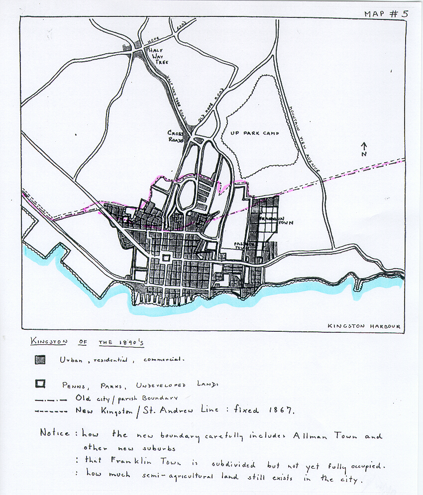
Outside of Kingston, two new centres for growth had sprung up. (See Map # 5) Cross Roads and Half-Way-Tree were, as their names suggest, strategic positions on the road system in lower St. Andrew. Half-Way-Tree was, in fact the capital of St. Andrew, but had very little besides a church and a court house. In 1823. Half-Way-Tree is "a burial ground and penns" [10], and nothing more. By 1883, another visitor, Lady Brassey, found Half-Way-Tree well on its way to losing its identity as a separate village. She describes it as "the fashionable quarter of Kingston" [11] , indicating that it now had the character of an upper class suburb, away from the noise and bustle of the downtown dock area of Kingston. Cross Roads, closer to the Kingston boundary, grew up in relation to the military establishment at Up Park Camp.
Half-Way-Tree and Cross Roads are representative of the form that urban growth would take in Kingston and St. Andrew for the next 75 years. They grew up at intersections in the communications network, and foreshadowed the impact that better communications and modern transportation would have on the spread of Kingston in the 20th century.
Between the suburb boom of the post-emancipation years and the establishment of Kingston as the capital in 1872, the city went through another period of relative stability. Trade with the Spanish colonies declined as they turned to more diverse markets. Sugar, the staple of the island's economy was declining in profitability; the slaves had been freed; many planters lost confidence in free labour. Severe drought did nothing to help the situation. Ironically, it is in this period of decline that Kingston became the capital of Jamaica. The Morant Bay Rebellion of 1865, and the subsequent Royal Commission of investigation 'demoted' Jamaica to the old status of a Crown Colony. With a strong gubernatorial hand at the wheel, instead of a fractious, planter-dominated assembly, the superiority of Kingston over Spanish Town was recognised.
In this stable period, there was one factor which contributed greatly to Kingston's growth -- fire. Some districts of Kingston were built almost entirely of wood, and the houses were very close together. Especially in the dry season, fire was a major hazard. Fires swept over Kingston in 1843, in 1863, and again in 1882. Each time fire cleaned out the small tenement yards of lower Kingston and new building appeared on the fringe of the city. It was fire which helped Kingston to fill in the many undeveloped plots within the city. After the fire of 1883, a cleaner and more solid Kingston rose from the ashes.
Kingston did make a few municipal improvements in this period. In 1848, a water supply was brought in from the Hope River, by a private company, the Kingston and Liguanea Water Works. [12] Previous to this, the city had relied on wells and cisterns for water, and had thus been very vulnerable to epidemics and to drought. After 1806, the City Council of Kingston, as well as all the parish vestries were replaced by Municipal Boards nominated by the executive. This was part of the tighter control that came in with the return to Crown Colony government.
In 1877, the streets and houses of Kingston were lighted by gas. The same year, saw the building of two public produce markets, the Victoria at the foot of King St. near the docks, and the Jubilee on the Northeast side of Parade. Later, in the decade of the 90's, under the able administration of Governor Sir Henry Arthur Blake, an underground system of drainage for Kingston was set up, a facility sorely needed, for the streets ran like gullies, and the gullies like the Amazon in heavy rain. By 1890, electric lights were beginning to take the place of gas in the principal buildings. [13] Street cars, drawn by mules, were the chief urban transport, even though the lines of the Jamaica Tramway Co. had already been laid, from the foot of King St. right up to Constant Spring in the foothills of the St. Andrew mountains. [14]
Improvements in communications and transport moved on apace. In 1876, animal-drawn trams appeared, and in 1899, electric streetcars were introduced. The routes were planned to meet existing, or readily anticipated demand. Thus the trams speeded up development in St. Andrew, but at the same time, froze the pattern of development to the existing arterial roads. Ribbon development occurred on all the major arteries in lower St. Andrew. The road to Half-Way-Tree was lined with villas, creating a spur of Kingstonoriented residence, that was eventually to engulf the village of Half-Way-Tree. Out along the Old Hope Road similar exclusive residential development took place. These depended on the improved transportation for linkage to the city. Better transport. especially trams, also encouraged the growth of lower and middle class subdivisions, such as had appeared after emancipation. There were still penns right in the heart of Kingston even in 1890. These penns began to break up in the late 1890's. Victoria Garden, Malvern Lands (1895), and Burke Town appeared in the East.
By 1906, Kingston had a much more impressive and modern appearance. A visitor commented on the "up-to-date 20th century, American electric cars, screaming along the roads" [15]. He compared Kingston in overall bustle and character to New York, only, of course, a New York "built by children in dolls'-house style" [16].
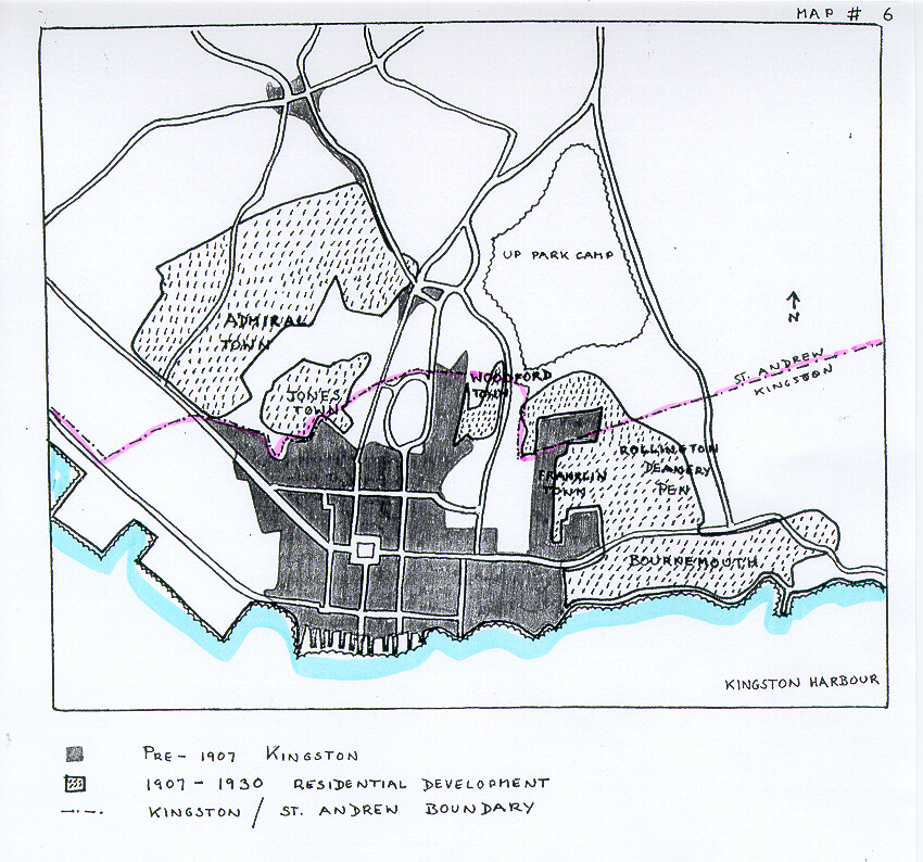
In 1907, an event of great importance for Kingston took place. There was an earthquake on a scale similar to the one that catapulted Kingston into existence in 1692. The earthquake of 1907 was followed by a fire which swept through Kingston, and outdid the earthquake in damage and destruction. Once more Kingston had the chance to start again from its smoking ruins. The main streets of the downtown area were almost entirely rebuilt. A completely new set of government buildings arose on King St. The earthquake accelerated the movement out of Kingston.'s city limits. There were now buildings. in the West and Northwest; Jones town, Admiral Town, and Craig Town appeared. In the east, the South Camp Road tram route spurred the growth of Woodford Town, and Campbell Town.
Another new development in transportation, the bicycle, also aided the growth of lower middle class areas, not on the tram routes, but close enough to the city centre to make bicycle commuting possible. Vineyard Town, Rollington Town and Franklin Town filled up. (See Map # 6) .
By 1913, a hierarchy was well established between residential neighbourhoods in Kingston. "The farther one gets away from the lower portions of the town, the finer the residences become" [17]. Kingston was at the time also developing another classic urban phenomenon, the slum. Many of the lanes of the old Kingston grid had now become slums [17]. But now there were slum-suburbs too. These developments combined the characteristics of village and slum, and were mainly peopled by very recent immigrants to the city. Hannah Town was such a slum-suburb at this time, [18] most of its buildings being little more than cardboard shacks.
From the first World War until the 1970's. Kingston spread wherever the current modes of transportation could take it. It spread out to produce the streets of Trench Town and Whitfield in the West, Kingston's largest and direst slum. But mainly it moved North. Half-Way-Tree was engulfed, and Kingston sent out a long arm along the Hope Road. At the end of the Hope Road the little village of Papine developed in much the same way that Cross Roads and Half-Way-Tree had before. It was the tram terminus, then the bus terminus. An important produce market grew up there. By the 1940's and 50's it had become eminently residential. The new University of the West Indies was built close by in the early 1950's.
By 1923, St. Andrew had become such a natural and undifferentiated suburb of Kingston, and was so unabashedly urban, that it had outgrown its parochial board. Instead of extending the boundaries of Kingston proper (as had been done in 1867) Kingston and St. Andrew were amalgamated to form one administrative unit, known as the Corporate Area. [19]
NOTES
6. Philip Curtin, Two Jamaicas (Cambridge, Mass., 1955) Excerpt from the Journal of a West Indian Proprietor, by Matthew Lewis. p. 162.
7. W. G. Sewall, The Ordeal Of Free Labour in The West Indies (New York, 1801) p. 175.
8. Cynric Williams, A Tour, p. 221.
9. Curtin, Two Jamaicas, p. 8.
10. Williams, p. 235.
11. Lady Brassey, In the Trades, the Tropics. and the Roaring 40's (New York 1885) p. 218-225.
12. Jacobs, Sixty Years. p. 80.
13. Bacon, The New Jamaica, p. 62.
14. Bacon, p. 64.
15. John Henderson, Jamaica (London. 1906) p. 13.
16. Ibid. p. 23.
17. H. G. DeLisser, Twentieth Century Jamaica (Kingston, Jamaica, 1913) p. 76.
18. Ibid. p. 122.
19. Frank Cundall, Jamaica in 1924 (Kingston, Jamaica, 1924) p. 67.
For the illustrated History of Kingston by Michelle Gadpaille, go to:
History of Kingston Part 1
History of Kingston Part 2
History of Kingston Part 3
History of Kingston Part 4
SEARCH THIS SITE
GO TO:
Help - Frequently Asked Questions
Jamaica Almanacs Slave-owners, Civil & Military officers, Magistrates etc.
Items in the Samples Directory
Items in the Members Directory
Transcriptions from Registers and Wills (Church of England, Dissenters, Civil Registration)
Jamaican Roman Catholic Church Registers - transcriptions
Jamaican Methodist Baptisms - transcriptions
Jewish births marriages deaths - transcriptions