Jamaican Family Search Genealogy Research Library
After this violent surge of expansion, Kingston stagnated for 70 years. The town did not outgrow its grid limits; it seemed set forever at that size and pattern. No one who was anyone lived in Kingston. Even the merchants and financiers of its shorefront lived, if humanly possible, outside the city limits in the green parish of St. Andrew. North of Parade, the Liguanea plain was subdivided into agricultural/ residential holdings, called 'penns', to which the businessmen of the city retired after a day's work. These penns were mainly dairy and market-garden plots, and produced meat and hides to supply the Navy and Military, as well as foodstuffs for the townsfolk. Kingston lacked a substantial lower-class population. Sugar plantations dominated the economy of the island, and kept the white middle class, as well as the only labouring class, the Negro slaves, anchored firmly to the country. The town was thus the resort of the free coloured section of the population, and of the few free blacks. The population increased only very slowly.
Then, at the beginning of the 19th century, three things happened to change the face of Kingston. First, Europe broke out in a rash of Revolutionary and Napoleonic Wars. Secondly, Napoleon turned on Spain, and, much later, (1834-1838) the slaves of the British West Indies were set free.
War had always been of benefit to Kingston, but the Revolutionary and Napoleonic wars were particularly so. Not only did war bring the usual bustle to keep the ship yards busy, but it brought new trade. When the French Island of St. Domingue revolted and became the black republic of Haiti in 1800-1801, French refugees came pouring into Kingston. They were often people who had been wealthy, but who had left their land behind in Haiti, and were therefore ready to start from scratch with the mobile capital (often considerable) that they had brought along. They invested in penns close to Kingston -- some of the French names are still there, among them, Desdunes, Devereux, Gadpaille and D'Aeth. [4] Moreover, these people became the first substantial upper-class element of Kingston society, and major merchants and retailers.
Napoleon helped the growth of Kingston along when he invaded Spain. The monopoly that Spain had enjoyed on trade with her extensive American colonies was rendered ineffectual. The Spanish-American colonies declared an economic independence from Spain, and turned to Britain for trade. Kingston became one of the main depots for carrying trade of the Spanish colonies. [5] The city grew under this economic stimulus. There was an influx of English and Scottish merchants and bisinessmen, who took up residence in the more northerly parts of the town, and swelled its small upper class.
Kingston had one problem in this boom time -- labour shortage. There just was not enough labour to go around. The free coloured and free blacks tended to assert their freedom by setting up in business for themselves. Most were self-employed in some small service occupation. The slave trade had stopped in 1808. All existing slaves were on the plantations. The docks were often staffed by 'job-gangs' of slaves, which were hired out by their masters.
This situation changed after full emancipation came in 1838. Jamaica now had mobile masses, many of whom moved into Kingston immediately after emancipation, and many more of whom drifted in after a few years on their own in the country. The labour problem was solved, unfortunately, just in time to see the end of the wartime boom. But Kingston grew, as new consumer demand sprung up. Retailing became a major occupation in a town now catering to individuals and not to plantation factors buying in bulk. Kingston became more residential then, than it had ever been.
As the masses moved into the lanes of Kingston behind the docks, the old middle class white and coloured people looked elsewhere. Whole new districts of residential character began to grow on the fringes of the town. Some received the old residents seeking to entrench themselves in privilege by being slightly farther away from the docks. Some were populated directly by the incoming masses, these districts remaining poorer and less prestigious to this day.
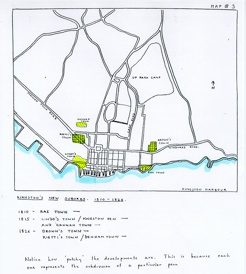
Kingston expanded by the break-up of its fringe 'penns'. Those closest to the city streets were subdivided, first into two smaller holdings, or 'villas', and then, perhaps, into a real urban subdivision with streets and blocks. This fringe development shattered forever the grid pattern of Kingston. The residential suburbs grew according to the size and shape of the penns which had been subdivided to create them.
As early as 1810, Rae Town appeared, following the general Eastward trend of the city. It was an upper-class suburb, built to house the Haitian immigrants, and the British merchants frightened out of Britain by Napoleon's Berlin Decrees of 1806. It was, significantly, the first coastal land of Kingston not to be appropriated as dock space. The waterfront here represented pleasure and not business. (Rae Town was later to lose its aristocratic character, but until the 1970's, it still housed the Royal Jamaica Yacht Club-- the ultimate symbol of aristocratic enjoyment of the coast.)
In the West, Lindo's Town, or Kingston Pen was another new development which had appeared by 1815. This was connected with a westerly extension of the waterfront, and was therefore a very working-class township, inhabited by free artisans, and possibly by jobbing slaves. The rest of the expansion of Kingston took place northwards, really the most logical direction in which to go.
Hannah Town was created in 1815, well across the town line, in lower St. Andrew. Closer to the centre of town, appeared Brown's Town in 1826, and Rietti's town to the North West. This last was the first and only part of Kingston to have streets named numerically. Abraham Rietti laid out 14 streets on his land, and laid them in relation to the slant of the Spanish Town Road, thus destroying all possibility for the westward grid extension of Kingston in the future. (See Map #3).
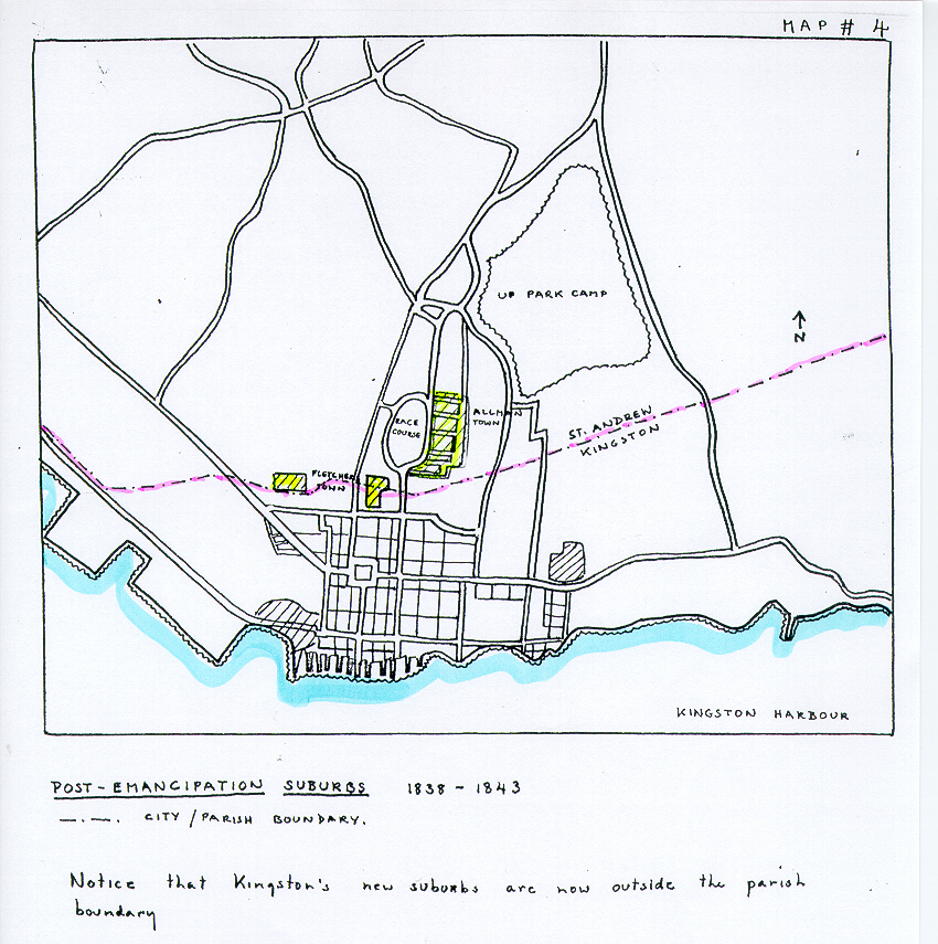
Emancipation came in 1834-1838, and the real post-Emancipation suburbs were Fletcher's Town, and Allman Town. (See Map # 4) This last was the largest and most ambitious scheme yet, covering an area equal in size to the large race course, now set up in Lower St. Andrew. Much of the new suburban development lay outside the boundaries of Kingston proper, and in 1867, a new boundary line was fixed for the town, by Law # 20, carefully bringing Hannah and Allman town under city jurisdiction.
NOTES
4. James H, Stark, Stark's History and Guide to Jamaica (Boston 1898) p. 60 (map) .
5. H. P. Jacobs, Sixty Years of Change (Jamaica, 1973) p. 2526.
For the illustrated History of Kingston by Michelle Gadpaille, go to:
History of Kingston Part 1
History of Kingston Part 2
History of Kingston Part 3
History of Kingston Part 4
SEARCH THIS SITE
GO TO:
Help - Frequently Asked Questions
Jamaica Almanacs Slave-owners, Civil & Military officers, Magistrates etc.
Items in the Samples Directory
Items in the Members Directory
Transcriptions from Registers and Wills (Church of England, Dissenters, Civil Registration)
Jamaican Roman Catholic Church Registers - transcriptions
Jamaican Methodist Baptisms - transcriptions
Jewish births marriages deaths - transcriptions