Jamaican Family Search Genealogy Research Library
EARLY MAPS OF SOUTHEASTERN WESTMORELAND
JAMAICA
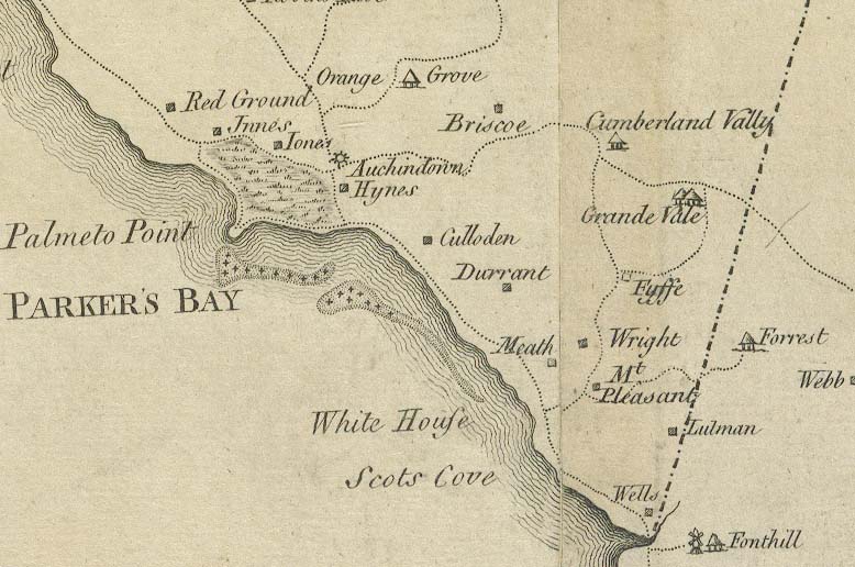
Auchindown
Briscoe
Culloden
Cumberland Valley
Durrant
Font Hill (St. Elizabeth)
Forrest (St. Elizabeth)
Fyffe
Grande Vale
Hynes
Innes
Jones
Lulman
Meath
Mt. Pleasant
Orange Grove
Palmeto Point
Parker's Bay (sea)
Red Ground
Scots Cove
Webb (St. Elizabeth)
Wells
White House (Bay)
Wright
Campbell's
P. Campbell's
Cowal's
Culloden
Forest (St. Elizabeth)
Grand-Vale
Grove's
Gun Point
Hoy's
Orange Grove
Parker's Bay (sea)
Peters-Ville
J. Smith's
Teague's Gully
Tomlinson's
John Wedderburn's
White House (Bay)
Wilkies
SEARCH THIS SITE
GO TO:
Help - Frequently Asked Questions
Jamaica Almanacs Slave-owners, Civil & Military officers, Magistrates etc.
Items in the Samples Directory
Items in the Members Directory
Transcriptions from Registers and Wills (Church of England, Dissenters, Civil Registration)
Jamaican Roman Catholic Church Registers - transcriptions
Jamaican Methodist Baptisms - transcriptions
Jewish births marriages deaths - transcriptions