Jamaican Family Search Genealogy Research Library
WESTERN HANOVER LAND GRANTS
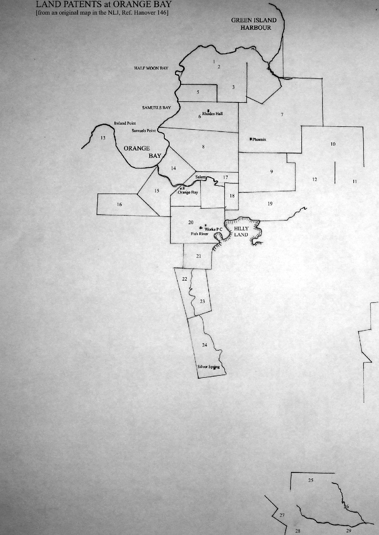
1. Captain Roger James 500 acres surveyed 6th February 1673 by L.C.
2. Patented by Dorothy Bannister 1674
3. Timothy Burt 19th Dec. 1717 sold said 500 acres to Rowland Williams
4. [Meredith] Davis 500 acres surveyed now belonging to Heirs of ____anye Resurveyed 30th June 1729
5. John Green & Jonathan Wright 120 acres at Orange Bay surveyed 4th January 1673
6. 500 acres part of 1000 acres patented by Dorothy Bannister 2nd Oct 1674 Timothy Burt of 19th Dec 1717 sold the same 500 acres to Rowland Williams - surveyed and laid out at the request of the Hon. John Campbell April 1729. Thomas Dunbar
7. Richard Buttler 1190 acres, for Henry Wells 1000 acres
8. 774 acres the remaining part of Warren's Plat patented by Dorothy Bannister 2nd Oct 1674 and belonging the Hon. John Campbell Esq. at whose instance and request the same is resurveyed - 3rd April 1729 T. Dunbar
9. 638 acres being the moiety of 1,276 acres Patented by Martin Howell resurveyed and divided for Mr James Witter 13th April 1729. Thomas Dunbar
10. George Fawcett _____surveyed the ___day of ___ 1674 L.C. ______now belonging to Leonard Vassall
11. ____now belonging to Leonard Vassall
12. Joseph Hunt 500 acres, surveyed 31 March 1674. L Claybourn
13. H Willis 420 acres East on Orange Bay to the West surrounded by sea & Morass formerly called [S____] now claimed by John Blessett at Lucea
14. M Lewis & Neil [___________] 200 acres surveyed, now to James Campbell Esq.
15. The Hon. John Campbell Esq,. 300 acres
16. James Campbell 300 acres, surveyed Jan. 19th 1727
17. 100 acres part of 100 acres patented by Dorothy Bannister for Mr James Witter
18. 100 acres part of [___ ____ _____] for Mr James Witter
19. 538 acres being the other part of said Howell's 1,276 acres resurveyed and divided for the Hon. John Campbell 15th April 1729. Thomas Dunbar
20. 500 acres part of 1000 patented By Dorothy Bannister 2nd Oct 1674, resurveyed for Mr Peter Campbell
21. 120 acres part of William Morris 249 acres enclosure of Clark's Plat being prior to 8th April 1729. T.D.
22. James Witter 157 acres surveyed by John Green
23. Mr James Witter 200 acres, surveyed by Jonathan Price
24. Daniel Arcedeckne 365 acres, surveyed 20th November 1719. D. Evans
25. John Johnston 500 acres, surveyed 6 September 1673
26. [L_____ _______] 1000 acres surveyed by John Vassall
27. James Cundall 90 acres, surveyed 20th December 1674
28. John Gale 360 acres, surveyed 26th February 1675 now Paul Stevens
29. John Hugh 300 acres, surveyed 1st May 1676. L.C.
SEARCH THIS SITE
GO TO:
Help - Frequently Asked Questions
Jamaica Almanacs Slave-owners, Civil & Military officers, Magistrates etc.
Items in the Samples Directory
Items in the Members Directory
Transcriptions from Registers and Wills (Church of England, Dissenters, Civil Registration)
Jamaican Roman Catholic Church Registers - transcriptions
Jamaican Methodist Baptisms - transcriptions
Jewish births marriages deaths - transcriptions